1
Geoclip
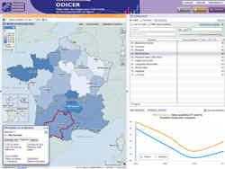
Den interaktive kortlægningsløsning med Géoclip foreslås af EMC3.Géoclip tillader at offentliggøre online tematiske atlas eller territoriale observatorier.
- Freemium
- Web
Den interaktive kortlægningsløsning med Géoclip foreslås af EMC3.Géoclip tillader at offentliggøre online tematiske atlas eller territoriale observatorier.Med Géoclip kan du opbygge applikationer til kortlægning af web til kartografiske repræsentationer af statistiske data.
Internet side:
http://www.geoclip.fr/an/index.phpFunktioner
Kategorier

Alternativer til Geoclip til Self-Hosted med kommerciel licens
0
hale connect
Cloud-platform til nem og effektiv transformation og publicering af Open Standards (INSPIRE, OGC, Smart Cities, BIM) data.
- Betalt
- Web
- Self-Hosted